চিত্র:Gaza Strip Access Restrictions.pdf

পূর্ণ রেজোলিউশন (৪,৯৫০ × ৭,০৮৫ পিক্সেল, ফাইলের আকার: ৪.৭৬ মেগাবাইট, এমআইএমই ধরন: application/pdf)
| এই ফাইলটি উইকিমিডিয়া কমন্স থেকে নেওয়া। সেখানের বর্ণনা পাতার বিস্তারিত নিম্নে দেখানো হলো। (সম্পাদনা)
|
সারাংশ
| বিবরণ |
Deutsch: Gazastreifen mit Zugangsbeschränkungen für seine Bewohner
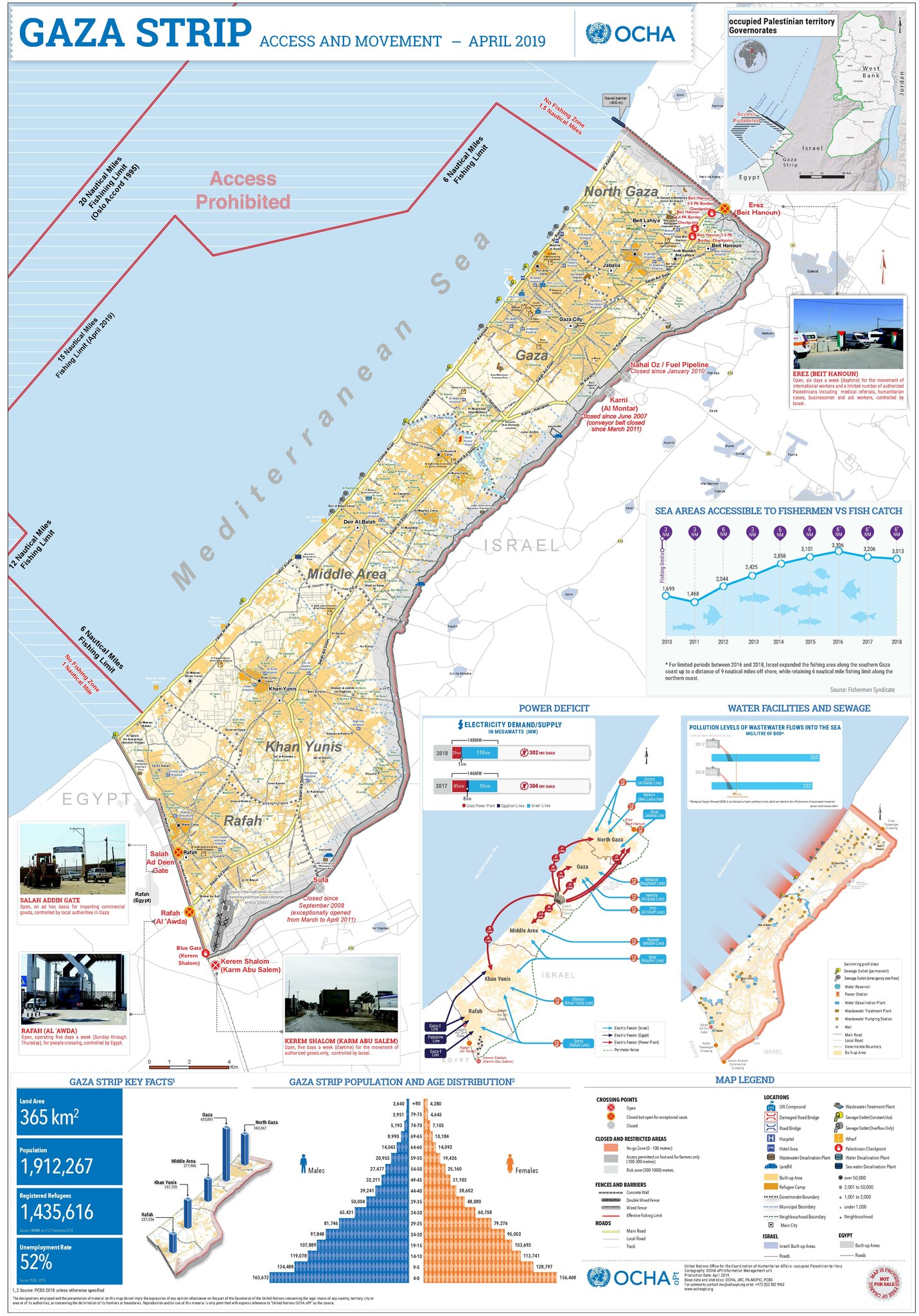
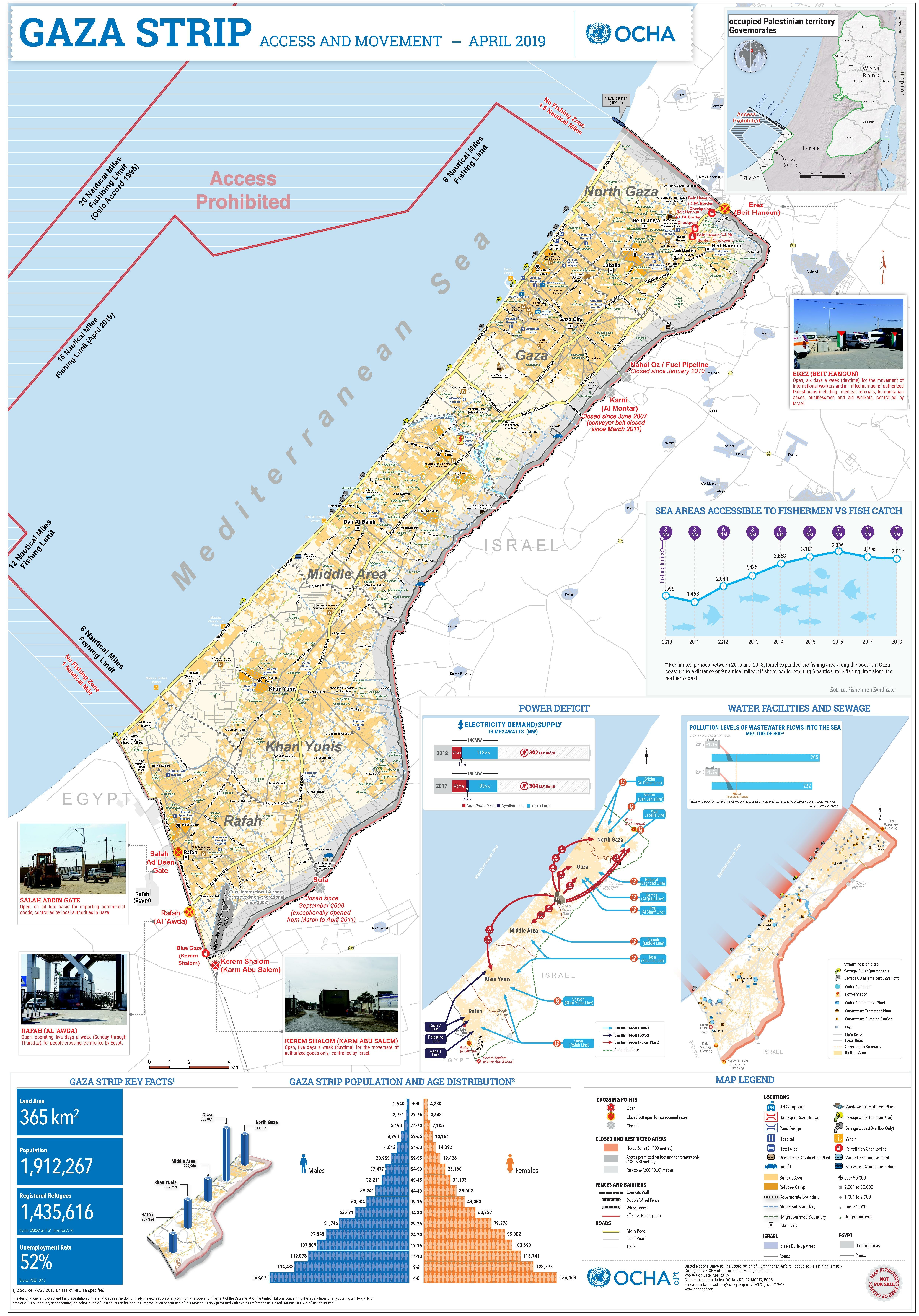
English: A map of the Gaza Strip and the access restrictions its residents have |
|||
| তারিখ | ||||
| উৎস | https://www.ochaopt.org/sites/default/files/Gaza_A0_2023.pdf | |||
| লেখক | United Nations Office for the Coordination of Humanitarian Affairs (OCHA) | |||
| অনুমতি (এ ফাইলের পুনঃব্যবহার) |
|

ফাইলের ইতিহাস
যেকোনো তারিখ/সময়ে ক্লিক করে দেখুন ফাইলটি তখন কী অবস্থায় ছিল।
| তারিখ/সময় | সংক্ষেপচিত্র | মাত্রা | ব্যবহারকারী | মন্তব্য | |
|---|---|---|---|---|---|
| বর্তমান | ১২:১৩, ১২ ডিসেম্বর ২০২৩ |  | ৪,৯৫০ × ৭,০৮৫ (৪.৭৬ মেগাবাইট) | Wickey | Reverted to version as of 21:42, 14 December 2020 (UTC). Different image; please put it in a new file |
| ১৫:২৭, ৮ অক্টোবর ২০২৩ |  | ৪,৯৫০ × ৭,০৮৫ (৬.৮ মেগাবাইট) | Isochrone | 2023 version from https://www.ochaopt.org/sites/default/files/Gaza_A0_2023.pdf | |
| ২১:৪২, ১৪ ডিসেম্বর ২০২০ |  | ৪,৯৫০ × ৭,০৮৫ (৪.৭৬ মেগাবাইট) | Veggies | {{Information |Description=A map of the Gaza Strip and the access restrictions its residents have |Source=https://www.ochaopt.org/sites/default/files/gaza_a0_press.pdf |Date=2019-05-07 |Author=United Nations Office for the Coordination of Humanitarian Affairs (OCHA) |Permission={{PD-UN-map}} |other_versions= }} |
সংযোগসমূহ
নিচের পৃষ্ঠা(গুলো) থেকে এই ছবিতে সংযোগ আছে:
ফাইলের বৈশ্বিক ব্যবহার
নিচের অন্যান্য উইকিগুলো এই ফাইলটি ব্যবহার করে:
- ar.wikipedia.org-এ ব্যবহার
- arz.wikipedia.org-এ ব্যবহার
- az.wikipedia.org-এ ব্যবহার
- ca.wikipedia.org-এ ব্যবহার
- da.wikipedia.org-এ ব্যবহার
- de.wikipedia.org-এ ব্যবহার
- el.wikipedia.org-এ ব্যবহার
- en.wikipedia.org-এ ব্যবহার
- eo.wikipedia.org-এ ব্যবহার
- es.wikipedia.org-এ ব্যবহার
- eu.wikipedia.org-এ ব্যবহার
- fa.wikipedia.org-এ ব্যবহার
- fi.wikipedia.org-এ ব্যবহার
- fr.wikipedia.org-এ ব্যবহার
- he.wikipedia.org-এ ব্যবহার
- id.wikipedia.org-এ ব্যবহার
- ja.wikipedia.org-এ ব্যবহার
- kk.wikipedia.org-এ ব্যবহার
- ms.wikipedia.org-এ ব্যবহার
- nl.wikipedia.org-এ ব্যবহার
- no.wikipedia.org-এ ব্যবহার
- pap.wikipedia.org-এ ব্যবহার
- sat.wikipedia.org-এ ব্যবহার
- tr.wikipedia.org-এ ব্যবহার
- zh.wikipedia.org-এ ব্যবহার