চিত্র:Earth oblateness to scale.svg

এই SVG ফাইলের জন্য এই PNG প্রাকদর্শনের আকার: ৫১২ × ৫১২ পিক্সেল। অন্যান্য আকারসমূহ: ২৪০ × ২৪০ পিক্সেল | ৪৮০ × ৪৮০ পিক্সেল | ৭৬৮ × ৭৬৮ পিক্সেল | ১,০২৪ × ১,০২৪ পিক্সেল | ২,০৪৮ × ২,০৪৮ পিক্সেল।
পূর্ণ রেজোলিউশন (এসভিজি ফাইল, সাধারণত ৫১২ × ৫১২ পিক্সেল, ফাইলের আকার: ২ কিলোবাইট)
| এই ফাইলটি উইকিমিডিয়া কমন্স থেকে নেওয়া। সেখানের বর্ণনা পাতার বিস্তারিত নিম্নে দেখানো হলো। (সম্পাদনা)
|
সারাংশ
| বিবরণ |
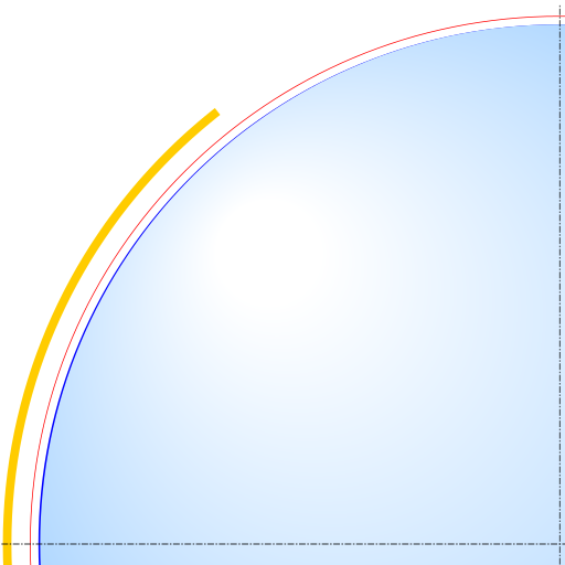
English: Scale drawing of the oblateness of the 2003 IERS reference ellipsoid. The outer edge of the dark blue line is an ellipse with the same eccentricity as that of the Earth, with North at the top. For comparison, the outer edge of the light blue area is a circle of diameter equal to the minor axis (a point on the equator, to its antipode). The red line denotes the Karman line (100 km altitude) and the yellow area, the range of the International Space Station (330-435 km altitude, 51.65-degree orbital inclination). |
| তারিখ | |
| উৎস | নিজের কাজ |
| লেখক | Cmglee |
লাইসেন্স প্রদান
আমি, এই কাজের স্বত্বাধিকারী, এতদ্দ্বারা আমি এই কাজকে নিম্ন বর্ণিত লাইসেন্সের আওতায় প্রকাশ করলাম:
এই ফাইলটি ক্রিয়েটিভ কমন্স অ্যাট্রিবিউশন-শেয়ার অ্যালাইক ৩.০ আনপোর্টেড লাইসেন্সের আওতায় লাইসেন্সকৃত।
- আপনি স্বাধীনভাবে:
- বণ্টন করতে পারেন – এ কাজটি অনুলিপি, বিতরণ এবং প্রেরণ করতে পারেন
- পুনঃমিশ্রণ করতে পারেন – কাজটি অভিযোজন করতে পারেন
- নিম্নের শর্তাবলীর ভিত্তিতে:
- স্বীকৃতিপ্রদান – আপনাকে অবশ্যই যথাযথ স্বীকৃতি প্রদান করতে হবে, লাইসেন্সের একটি লিঙ্ক সরবরাহ করতে হবে এবং কোনো পরিবর্তন হয়েছে কিনা তা নির্দেশ করতে হবে। আপনি যেকোনো যুক্তিসঙ্গত পদ্ধতিতে এটি করতে পারেন। কিন্তু এমন ভাবে নয়, যাতে প্রকাশ পায় যে লাইসেন্সধারী আপনাকে বা আপনার এই ব্যবহারের জন্য অনুমোদন দিয়েছে।
- একইভাবে বণ্টন – আপনি যদি কাজটি পুনঃমিশ্রণ, রুপান্তর, বা এর ওপর ভিত্তি করে নতুন সৃষ্টিকর্ম তৈরি করেন, তবে আপনাকে অবশ্যই আপনার অবদান একই লাইসেন্স বা একই রকমের লাইসেন্সের আওতায় বিতরণ করতে হবে।

|
এই নথি অনুলিপি, বিতরণ এবং/বা পরিবর্তন করার অনুমতি ফ্রি সফটওয়্যার ফাউন্ডেশন কর্তৃক প্রকাশিত গনু ফ্রি ডকুমেন্টেশন লাইসেন্স, সংস্করণ ১.২ বা তার পরবর্তী সংস্করণের আওতায় অনুমতিপ্রাপ্ত; যে কোনো রকম অনুচ্ছেদ পরিবর্তন, সম্মুখ-প্রচ্ছদের লেখা, পিছন-প্রচ্ছদের লেখা পরিবর্তন করা ছাড়াই। এই লাইসেন্সের একটি অনুলিপি গনু ফ্রি ডকুমেন্টেশন লাইসেন্স শিরোনামের অনুচ্ছেদে অন্তর্ভুক্ত করা আছে। |
আপনি আপনার পছন্দসই লাইসেন্স নির্বাচন করতে পারেন।
ফাইলের ইতিহাস
যেকোনো তারিখ/সময়ে ক্লিক করে দেখুন ফাইলটি তখন কী অবস্থায় ছিল।
| তারিখ/সময় | সংক্ষেপচিত্র | মাত্রা | ব্যবহারকারী | মন্তব্য | |
|---|---|---|---|---|---|
| বর্তমান | ২৩:৫২, ২৯ মার্চ ২০১৫ | | ৫১২ × ৫১২ (২ কিলোবাইট) | Cmglee | Show more of ISS domain. |
| ২৩:৪২, ২৯ মার্চ ২০১৫ |  | ৫১২ × ৫১২ (২ কিলোবাইট) | Cmglee | {{Information |Description ={{en|1=Scale drawing of the oblateness of a reference geoid. The outer edge of the dark blue line is an ellipse with the same eccentricity as that of the Earth, with north at the top, For comparison, the outer edge of lig... |
সংযোগসমূহ
নিচের পৃষ্ঠা(গুলো) থেকে এই ছবিতে সংযোগ আছে:
ফাইলের বৈশ্বিক ব্যবহার
নিচের অন্যান্য উইকিগুলো এই ফাইলটি ব্যবহার করে:
- ar.wikipedia.org-এ ব্যবহার
- az.wikipedia.org-এ ব্যবহার
- bg.wikipedia.org-এ ব্যবহার
- da.wikipedia.org-এ ব্যবহার
- en.wikipedia.org-এ ব্যবহার
- es.wikipedia.org-এ ব্যবহার
- pt.wikipedia.org-এ ব্যবহার
- sk.wikipedia.org-এ ব্যবহার
- sv.wikipedia.org-এ ব্যবহার
- tr.wikipedia.org-এ ব্যবহার