চিত্র:Dallas County Texas Incorporated Areas Dallas highlighted.svg

এই SVG ফাইলের জন্য এই PNG প্রাকদর্শনের আকার: ৮০০ × ৪৫৭ পিক্সেল। অন্যান্য আকারসমূহ: ৩২০ × ১৮৩ পিক্সেল | ৬৪০ × ৩৬৬ পিক্সেল | ১,০২৪ × ৫৮৫ পিক্সেল | ১,২৮০ × ৭৩১ পিক্সেল | ২,৫৬০ × ১,৪৬৩ পিক্সেল।
পূর্ণ রেজোলিউশন (এসভিজি ফাইল, সাধারণত ১,০৫০ × ৬০০ পিক্সেল, ফাইলের আকার: ২৪৮ কিলোবাইট)
| এই ফাইলটি উইকিমিডিয়া কমন্স থেকে নেওয়া। সেখানের বর্ণনা পাতার বিস্তারিত নিম্নে দেখানো হলো। (সম্পাদনা)
|
সারাংশ
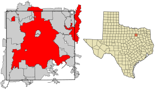
| বিবরণ | This map shows the incorporated areas in Dallas County, Texas. Dallas is highlighted in red. I created it in Inkscape using data from the following links: North Central Texas Council of Governments Maps Website, Dallas County Commissioner District Map (PDF) |
| তারিখ | |
| উৎস | My own work, based on government information. Though I strove to be as accurate in the detail as possible, the information shown is not guaranteed to be completely accurate. |
| লেখক | Ixnayonthetimmay |
| অনুমতি (এ ফাইলের পুনঃব্যবহার) |
Public Domain |
| অন্যান্য সংস্করণ | See Category:Maps of Dallas County, Texas for other versions of this image. |
লাইসেন্স প্রদান
| আমি, এই কাজের স্বত্বাধিকারী, এতদ্দ্বারা আমি এই কাজকে পাবলিক ডোমেইন লাইসেন্সের আওতায় প্রকাশ করলাম। এটি বিশ্বব্যাপী প্রযোজ্য হবে। কিছু দেশে এটি আইনত সিদ্ধ নাও হতে পারে, যদি তাই হয়: আমি যে-কাউকে এই কাজটি যেকোনো উদ্দেশ্যে, বিনাশর্তে ব্যবহারের অনুমতি প্রদান করছি, যদি না সেই শর্তগুলো আইনত প্রয়োজনীয় হয়। |
ফাইলের ইতিহাস
যেকোনো তারিখ/সময়ে ক্লিক করে দেখুন ফাইলটি তখন কী অবস্থায় ছিল।
| তারিখ/সময় | সংক্ষেপচিত্র | মাত্রা | ব্যবহারকারী | মন্তব্য | |
|---|---|---|---|---|---|
| বর্তমান | ১৮:২৭, ৯ আগস্ট ২০০৭ | | ১,০৫০ × ৬০০ (২৪৮ কিলোবাইট) | Ixnayonthetimmay | == Summary == {{Information |Description=This map shows the incorporated areas in Dallas County, Texas. Dallas is highlighted in red. I created it in [[en:Inkscape|Inkscape] |
সংযোগসমূহ
নিচের পৃষ্ঠা(গুলো) থেকে এই ছবিতে সংযোগ আছে:
ফাইলের বৈশ্বিক ব্যবহার
নিচের অন্যান্য উইকিগুলো এই ফাইলটি ব্যবহার করে:
- als.wikipedia.org-এ ব্যবহার
- ar.wikipedia.org-এ ব্যবহার
- br.wikipedia.org-এ ব্যবহার
- ckb.wikipedia.org-এ ব্যবহার
- de.wikipedia.org-এ ব্যবহার
- en.wikipedia.org-এ ব্যবহার
- fa.wikipedia.org-এ ব্যবহার
- fi.wikipedia.org-এ ব্যবহার
- fo.wikipedia.org-এ ব্যবহার
- fr.wikipedia.org-এ ব্যবহার
- fy.wikipedia.org-এ ব্যবহার
- he.wikipedia.org-এ ব্যবহার
- id.wikipedia.org-এ ব্যবহার
- io.wikipedia.org-এ ব্যবহার
- it.wikipedia.org-এ ব্যবহার
- ja.wikipedia.org-এ ব্যবহার
- ln.wikipedia.org-এ ব্যবহার
- lv.wikipedia.org-এ ব্যবহার
- ml.wikipedia.org-এ ব্যবহার
- ms.wikipedia.org-এ ব্যবহার
- my.wikipedia.org-এ ব্যবহার
- nl.wikipedia.org-এ ব্যবহার
- no.wikipedia.org-এ ব্যবহার
- pnb.wikipedia.org-এ ব্যবহার
- pt.wikipedia.org-এ ব্যবহার
- qu.wikipedia.org-এ ব্যবহার
- ro.wikipedia.org-এ ব্যবহার
- sco.wikipedia.org-এ ব্যবহার
- sc.wikipedia.org-এ ব্যবহার
- sl.wikipedia.org-এ ব্যবহার
- smn.wikipedia.org-এ ব্যবহার
- srn.wikipedia.org-এ ব্যবহার
- sv.wikipedia.org-এ ব্যবহার
- ta.wikipedia.org-এ ব্যবহার
- te.wikipedia.org-এ ব্যবহার
- th.wikipedia.org-এ ব্যবহার
- tl.wikipedia.org-এ ব্যবহার
- tr.wikipedia.org-এ ব্যবহার
- ug.wikipedia.org-এ ব্যবহার
- ur.wikipedia.org-এ ব্যবহার
- vi.wikipedia.org-এ ব্যবহার
- yo.wikipedia.org-এ ব্যবহার