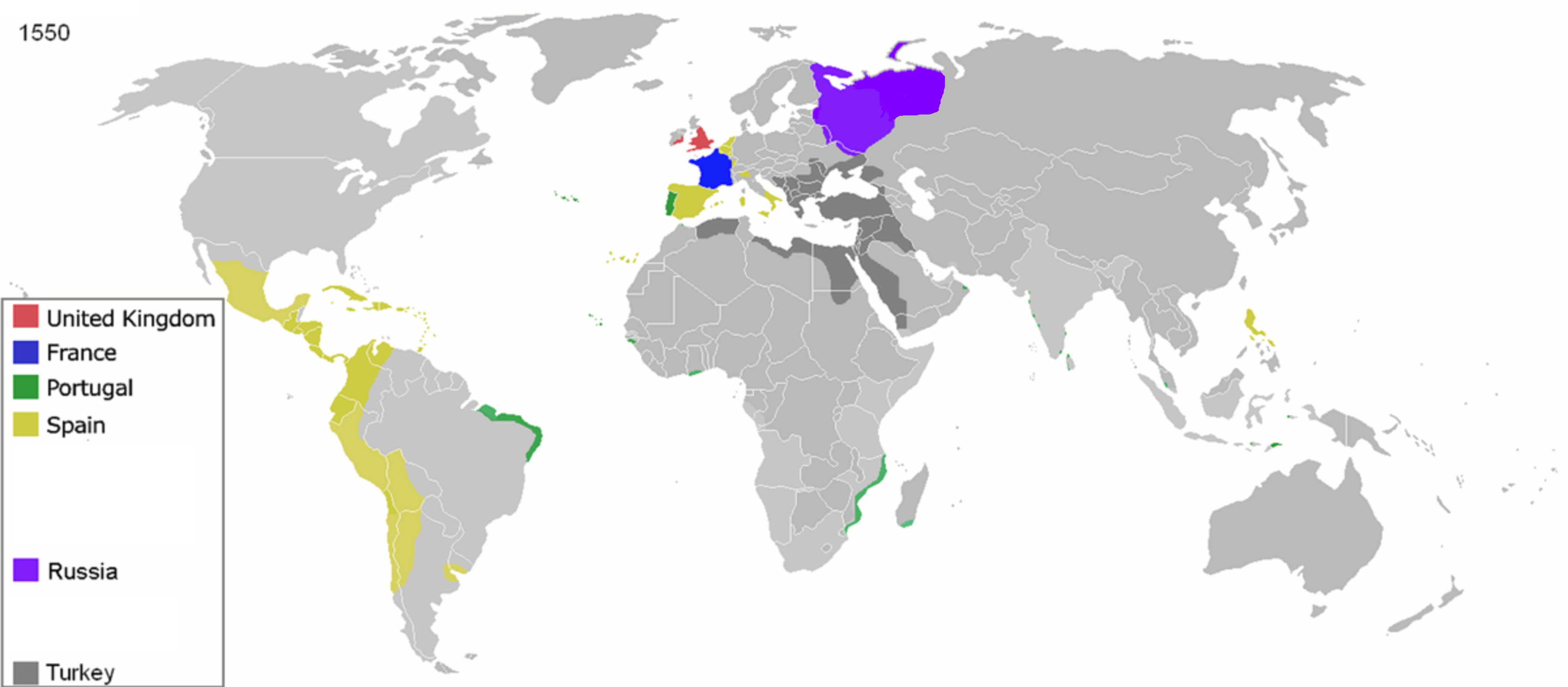
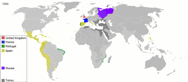
চিত্র:Colonisation 1550.png
পূর্ণ রেজোলিউশন (৩,৬০০ × ১,৫৭৮ পিক্সেল, ফাইলের আকার: ১.১৪ মেগাবাইট, এমআইএমই ধরন: image/png)
| এই ফাইলটি উইকিমিডিয়া কমন্স থেকে নেওয়া। সেখানের বর্ণনা পাতার বিস্তারিত নিম্নে দেখানো হলো। (সম্পাদনা)
|
| বিবরণ |
Map of major world powers by year
As the orriginal licence of the animation was Public Domain, this image which has been derived from it is too:
|
||||||||||||||||||
| তারিখ | |||||||||||||||||||
| উৎস | public domain animated map by ArdadN here | ||||||||||||||||||
| লেখক | ArdadN | ||||||||||||||||||
.jpg)
._LOC_2001620596.jpg)

|
This historical map image could be re-created using vector graphics as an SVG file. This has several advantages; see Commons:Media for cleanup for more information. If an SVG form of this image is available, please upload it and afterwards replace this template with
{{vector version available|new image name}}.
It is recommended to name the SVG file “Colonisation 1550.svg”—then the template Vector version available (or Vva) does not need the new image name parameter. |
ফাইলের ইতিহাস
যেকোনো তারিখ/সময়ে ক্লিক করে দেখুন ফাইলটি তখন কী অবস্থায় ছিল।
| তারিখ/সময় | সংক্ষেপচিত্র | মাত্রা | ব্যবহারকারী | মন্তব্য | |
|---|---|---|---|---|---|
| বর্তমান | ১১:৩২, ২৬ এপ্রিল ২০২০ | | ৩,৬০০ × ১,৫৭৮ (১.১৪ মেগাবাইট) | Ориенталист | Clarified the territory of Russia by 1550 |
| ০৯:২৫, ৫ এপ্রিল ২০২০ |  | ৩,৬০০ × ১,৫৭৮ (১.১৪ মেগাবাইট) | Ориенталист | cosmetic changes | |
| ১৪:৫৫, ২৭ মার্চ ২০২০ |  | ৪,২৭৫ × ১,৮৭৫ (১.০৫ মেগাবাইট) | Ориенталист | Clarified the territory of Russia. | |
| ২৩:২৫, ৩ মে ২০১০ |  | ১,৪২৫ × ৬২৫ (৭৩ কিলোবাইট) | Kieran4 | Fixed errors. | |
| ১০:৪০, ২২ মার্চ ২০০৭ |  | ১,৪২৫ × ৬২৫ (৬৫ কিলোবাইট) | Roke~commonswiki | {{Information |Description=Map of major world powers by year {{Maps of world history}} As the orriginal licence of the animation was Public Domain, this image which has been derived from it is too: {{PD-User|Andrei nacu}} |Source=public domain animated m |
সংযোগসমূহ
নিচের পৃষ্ঠা(গুলো) থেকে এই ছবিতে সংযোগ আছে:
ফাইলের বৈশ্বিক ব্যবহার
নিচের অন্যান্য উইকিগুলো এই ফাইলটি ব্যবহার করে:
- af.wikipedia.org-এ ব্যবহার
- ast.wikipedia.org-এ ব্যবহার
- bs.wikipedia.org-এ ব্যবহার
- cs.wikipedia.org-এ ব্যবহার
- de.wikipedia.org-এ ব্যবহার
- en.wikipedia.org-এ ব্যবহার
- es.wikipedia.org-এ ব্যবহার
- fa.wikipedia.org-এ ব্যবহার
- fr.wikipedia.org-এ ব্যবহার
- he.wikipedia.org-এ ব্যবহার
- kk.wikipedia.org-এ ব্যবহার
- mg.wikipedia.org-এ ব্যবহার
- no.wikipedia.org-এ ব্যবহার
- pt.wikipedia.org-এ ব্যবহার
- sk.wikipedia.org-এ ব্যবহার