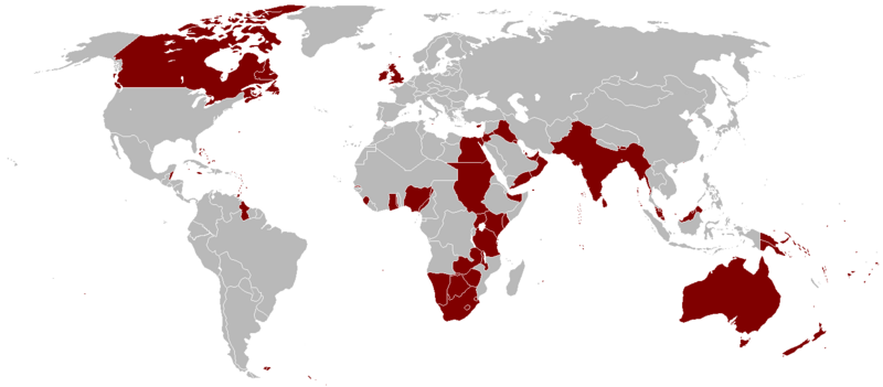
চিত্র:British Empire 1921.png

এই প্রাকদর্শনের আকার: ৮০০ × ৩৫১ পিক্সেল। অন্যান্য আকারসমূহ: ৩২০ × ১৪০ পিক্সেল | ৬৪০ × ২৮১ পিক্সেল | ১,৪২৫ × ৬২৫ পিক্সেল।
পূর্ণ রেজোলিউশন (১,৪২৫ × ৬২৫ পিক্সেল, ফাইলের আকার: ৫৮ কিলোবাইট, এমআইএমই ধরন: image/png)
ফাইলের ইতিহাস
যেকোনো তারিখ/সময়ে ক্লিক করে দেখুন ফাইলটি তখন কী অবস্থায় ছিল।
| তারিখ/সময় | সংক্ষেপচিত্র | মাত্রা | ব্যবহারকারী | মন্তব্য | |
|---|---|---|---|---|---|
| বর্তমান | ০৩:১৪, ৭ অক্টোবর ২০২৩ |  | ১,৪২৫ × ৬২৫ (৫৮ কিলোবাইট) | Alanzx123 | added weihaiwei |
| ১১:৪৫, ২৫ জুলাই ২০২৩ |  | ১,৪২৫ × ৬২৫ (৪০ কিলোবাইট) | Przemko1 | Bhutan, Sikkim british protectorates | |
| ০৮:০২, ৩১ অক্টোবর ২০২১ |  | ১,৪২৫ × ৬২৫ (৪০ কিলোবাইট) | Randomastwritter | juba | |
| ২২:০৫, ১৪ মার্চ ২০১৯ |  | ১,৪২৫ × ৬২৫ (৫৬ কিলোবাইট) | Horserice | Fixed Hong Kong. | |
| ১৬:২৭, ৫ জুন ২০১৭ |  | ১,৪২৫ × ৬২৫ (৩১ কিলোবাইট) | Maproom | Altered borders between Egypt, Libya and Sudan to agree with File:BlankMap-World-1921.png, which supposedly shows the correct borders as at 1921. | |
| ১৯:৪৪, ১১ ডিসেম্বর ২০১৫ |  | ১,৪২৫ × ৬২৫ (৩২ কিলোবাইট) | Braganza | Tibet existed until 1949 | |
| ১৯:৩৫, ৩ সেপ্টেম্বর ২০১৫ |  | ১,৪২৫ × ৬২৫ (৩৫ কিলোবাইট) | फ़िलप्रो | Fixed Nepal, Sikkim, and Bhutan. They were de facto princely states / protectorates of the British Empire. | |
| ২১:০২, ২৬ মার্চ ২০১৫ |  | ১,৪২৫ × ৬২৫ (৩৯ কিলোবাইট) | David C. S. | Ecudor in 1921 | |
| ১৯:০০, ৭ মে ২০১১ |  | ১,৪২৫ × ৬২৫ (৪৯ কিলোবাইট) | Quigley | Correct China's borders closer to what was internationally recognized at the time | |
| ০১:৩৩, ১৩ অক্টোবর ২০১০ |  | ১,৪২৫ × ৬২৫ (৫০ কিলোবাইট) | Vadac | Uploaded a clearer version with traditional British colour, added critical islands in Pacific and Caribbean and fixed the boarders of countries at the time such as Tuva among others |
সংযোগসমূহ
নিচের পৃষ্ঠা(গুলো) থেকে এই ছবিতে সংযোগ আছে:
ফাইলের বৈশ্বিক ব্যবহার
নিচের অন্যান্য উইকিগুলো এই ফাইলটি ব্যবহার করে:
- af.wikipedia.org-এ ব্যবহার
- als.wikipedia.org-এ ব্যবহার
- am.wikipedia.org-এ ব্যবহার
- ar.wikipedia.org-এ ব্যবহার
- ast.wikipedia.org-এ ব্যবহার
- azb.wikipedia.org-এ ব্যবহার
- az.wikipedia.org-এ ব্যবহার
- bg.wikipedia.org-এ ব্যবহার
- br.wikipedia.org-এ ব্যবহার
- ca.wikipedia.org-এ ব্যবহার
- cs.wikipedia.org-এ ব্যবহার
- da.wikipedia.org-এ ব্যবহার
- de.wikipedia.org-এ ব্যবহার
- el.wikipedia.org-এ ব্যবহার
- en.wikipedia.org-এ ব্যবহার
এই ফাইলের অন্যান্য বৈশ্বিক ব্যবহার দেখুন।
