চিত্র:Arab World Green.svg

এই SVG ফাইলের জন্য এই PNG প্রাকদর্শনের আকার: ৮০০ × ৪০৬ পিক্সেল। অন্যান্য আকারসমূহ: ৩২০ × ১৬২ পিক্সেল | ৬৪০ × ৩২৫ পিক্সেল | ১,০২৪ × ৫২০ পিক্সেল | ১,২৮০ × ৬৫০ পিক্সেল | ২,৫৬০ × ১,২৯৯ পিক্সেল | ৯৪০ × ৪৭৭ পিক্সেল।
পূর্ণ রেজোলিউশন (এসভিজি ফাইল, সাধারণত ৯৪০ × ৪৭৭ পিক্সেল, ফাইলের আকার: ৪০৪ কিলোবাইট)
| এই ফাইলটি উইকিমিডিয়া কমন্স থেকে নেওয়া। সেখানের বর্ণনা পাতার বিস্তারিত নিম্নে দেখানো হলো। (সম্পাদনা)
|
সারাংশ
| বিবরণ |
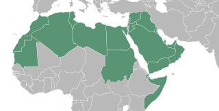
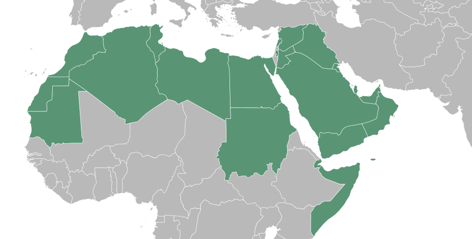
English: A map showing a portion of the Islamic world, North African country's are inhabited by the Amazigh an minority among them identified them self as Arab, in many cases it's what the feel despite not having an Semitic Middle eastern DNA. Egyptians are not Arabian either, but you have to understand they became Arab by culture. Last but not least the Middle East where the Arab originated from. The Islamic world has so many different race's that it is impossible to talk about an Arab world while the majority of the Muslims is not of Arab decent. The Islamic world is very cultural and racial diverse. It is their religion and spiritual bond that comes with it what connects them. Because of that, it's more appropriate and polite to talk about the Islamic world because that is what connects them. Besides that there is no Arabian Empire that rules over the whole Islamic world.
العربية: خريطة العالم العرب
ქართული: არაბული სამყაროს რუკა |
| তারিখ | |
| উৎস |
এই ভেক্টর চিত্রের অন্তর্ভুক্ত উপাদানটি |
| লেখক | T.seppelt |
| অন্যান্য সংস্করণ |
|
| SVG genesis |

লাইসেন্স প্রদান
| আমি, এই কাজের স্বত্বাধিকারী, এতদ্দ্বারা আমি এই কাজকে পাবলিক ডোমেইন লাইসেন্সের আওতায় প্রকাশ করলাম। এটি বিশ্বব্যাপী প্রযোজ্য হবে। কিছু দেশে এটি আইনত সিদ্ধ নাও হতে পারে, যদি তাই হয়: আমি যে-কাউকে এই কাজটি যেকোনো উদ্দেশ্যে, বিনাশর্তে ব্যবহারের অনুমতি প্রদান করছি, যদি না সেই শর্তগুলো আইনত প্রয়োজনীয় হয়। |
ফাইলের ইতিহাস
যেকোনো তারিখ/সময়ে ক্লিক করে দেখুন ফাইলটি তখন কী অবস্থায় ছিল।
| তারিখ/সময় | সংক্ষেপচিত্র | মাত্রা | ব্যবহারকারী | মন্তব্য | |
|---|---|---|---|---|---|
| বর্তমান | ১০:৪৯, ৩ সেপ্টেম্বর ২০২২ | | ৯৪০ × ৪৭৭ (৪০৪ কিলোবাইট) | SahinBasaran | Reverted to version as of 02:46, 3 September 2022 (UTC) |
| ১০:৪৯, ৩ সেপ্টেম্বর ২০২২ |  | ১,৯২০ × ৯৭৪ (৩১১ কিলোবাইট) | SahinBasaran | Reverted to version as of 21:05, 2 September 2022 (UTC) | |
| ১০:৪৮, ৩ সেপ্টেম্বর ২০২২ |  | ২,৪০০ × ১,২১৮ (৪৪০ বাইট) | SahinBasaran | Reverted to version as of 21:00, 2 September 2022 (UTC) | |
| ০২:৪৬, ৩ সেপ্টেম্বর ২০২২ |  | ৯৪০ × ৪৭৭ (৪০৪ কিলোবাইট) | M.Bitton | Reverted to version as of 03:34, 21 February 2016 (UTC): please don't perform tests on stable maps | |
| ২১:০৫, ২ সেপ্টেম্বর ২০২২ |  | ১,৯২০ × ৯৭৪ (৩১১ কিলোবাইট) | SahinBasaran | Added Israel, Malta and Somaliland. | |
| ২১:০০, ২ সেপ্টেম্বর ২০২২ |  | ২,৪০০ × ১,২১৮ (৪৪০ বাইট) | SahinBasaran | Added Israel, Malta and Somaliland. | |
| ০৩:৩৪, ২১ ফেব্রুয়ারি ২০১৬ |  | ৯৪০ × ৪৭৭ (৪০৪ কিলোবাইট) | Turnless | Fix format | |
| ২০:৪৫, ১১ এপ্রিল ২০১৫ |  | ৯৪০ × ৪৭৭ (৪৩১ কিলোবাইট) | T.seppelt | {{Information |Description ={{en|1=a map of the Arab World}} |Source ={{Attrib |1=BlankMap-Middle East.svg |2=NuclearVacuum }} |Author =T.seppelt |Date =2015-04-11 |Permission = |other_versions =[[:Fi... |
সংযোগসমূহ
নিচের পৃষ্ঠা(গুলো) থেকে এই ছবিতে সংযোগ আছে:
ফাইলের বৈশ্বিক ব্যবহার
নিচের অন্যান্য উইকিগুলো এই ফাইলটি ব্যবহার করে:
- af.wikipedia.org-এ ব্যবহার
- als.wikipedia.org-এ ব্যবহার
- arc.wikipedia.org-এ ব্যবহার
- ar.wikipedia.org-এ ব্যবহার
- arz.wikipedia.org-এ ব্যবহার
- az.wiktionary.org-এ ব্যবহার
- bg.wikipedia.org-এ ব্যবহার
- bs.wikipedia.org-এ ব্যবহার
- de.wikipedia.org-এ ব্যবহার
- de.wikinews.org-এ ব্যবহার
- Portal:Tunesien
- Portal:Irak
- Portal:Libanon
- Portal:Syrien
- Portal:Sudan
- Portal:Somalia
- Portal:Ägypten
- Portal:Saudi-Arabien
- Portal:Jemen
- Portal:Vereinigte Arabische Emirate
- Wikinews:Archiv/Hauptseite/2011/02
- Portal:Arabische Welt
- Vorlage:Portalnavigationsleiste Arabische Welt
- Wikinews:Pressestammtisch/Archiv/2011/Februar
- Portal:Libyen
- en.wikipedia.org-এ ব্যবহার
- en.wiktionary.org-এ ব্যবহার
- es.wikipedia.org-এ ব্যবহার
- fa.wikipedia.org-এ ব্যবহার
- fa.wikiquote.org-এ ব্যবহার
- fr.wikipedia.org-এ ব্যবহার
- fy.wikipedia.org-এ ব্যবহার
- gl.wikipedia.org-এ ব্যবহার
- he.wikipedia.org-এ ব্যবহার
- hu.wikipedia.org-এ ব্যবহার
- hy.wikipedia.org-এ ব্যবহার
এই ফাইলের অন্যান্য বৈশ্বিক ব্যবহার দেখুন।