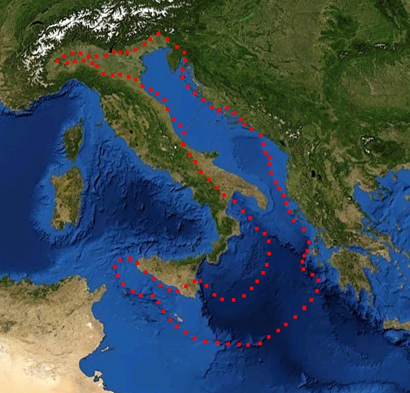
চিত্র:Adriatic Plate.jpg
এই প্রাকদর্শনের আকার: ৬২৬ × ৬০০ পিক্সেল। অন্যান্য আকারসমূহ: ২৫০ × ২৪০ পিক্সেল | ৫০১ × ৪৮০ পিক্সেল | ৮১৭ × ৭৮৩ পিক্সেল।
পূর্ণ রেজোলিউশন (৮১৭ × ৭৮৩ পিক্সেল, ফাইলের আকার: ১৮১ কিলোবাইট, এমআইএমই ধরন: image/jpeg)
| এই ফাইলটি উইকিমিডিয়া কমন্স থেকে নেওয়া। সেখানের বর্ণনা পাতার বিস্তারিত নিম্নে দেখানো হলো। (সম্পাদনা)
|
সারাংশ
| বিবরণ |
English: boundaries of the Adriatic plate
עברית: גבולות הלוח האדריאטי |
| তারিখ | (UTC) |
| উৎস |
Mediterranian_Sea_16.61811E_38.99124N.jpg (July 2012). "Present kinematics of Central and Northern Italy from continuous GPS measurements". Journal of Geodynamics 58: 62-72. Elsevier. ISSN 0264-3707. Retrieved on 12 March 2012. plate boundary map preview |
| লেখক |
|
| এটি একটি পুনঃসম্পাদিত চিত্র, যার মানে হল যে এটি ডিজিটালরূপে এটির মূল সংস্করণ থেকে পরিবর্তন করা হয়েছে। পরিবর্তন: crop, plate boundaries। আসলটি দেখা যাবে এখানে: Mediterranian Sea 16.61811E 38.99124N.jpg। דקי কর্তৃক এটি পরিবর্তিত হয়েছে।
|
লাইসেন্স প্রদান
| This image is in the public domain because it is a screenshot from NASA’s globe software World Wind using a public domain layer, such as Blue Marble, MODIS, Landsat, SRTM, USGS or GLOBE.
|
 |
| This work was previously under Public Domain, or a Free License. It has been digitally enhanced and/or modified. This derivative work has been (or is hereby) released into the public domain by its author, [[:{{{1}}}:User:{{{3}}}|{{{3}}}]] at the [[:{{{1}}}:|{{{2}}}]] project. This applies worldwide. In some countries this is not legally possible; if so:
|
মূল আপলোড লগ
This image is a derivative work of the following images:
- File:Mediterranian_Sea_16.61811E_38.99124N.jpg licensed with PD-WorldWind, PD-retouched-user-w
Uploaded with derivativeFX
ফাইলের ইতিহাস
যেকোনো তারিখ/সময়ে ক্লিক করে দেখুন ফাইলটি তখন কী অবস্থায় ছিল।
| তারিখ/সময় | সংক্ষেপচিত্র | মাত্রা | ব্যবহারকারী | মন্তব্য | |
|---|---|---|---|---|---|
| বর্তমান | ১৭:৫২, ২৯ ডিসেম্বর ২০১১ | | ৮১৭ × ৭৮৩ (১৮১ কিলোবাইট) | דקי | == {{int:filedesc}} == {{Information |Description={{en|boundaries of the Adriatic plate}} {{he|גבולות הלוח האדריאטי}} |Source=*File:Mediterranian_Sea_16.61811E_38.99124N.jpg |Date=2011-12-29 17:47 (UTC) |Author=*[[:File:Mediterrani |
সংযোগসমূহ
নিচের পৃষ্ঠা(গুলো) থেকে এই ছবিতে সংযোগ আছে:
ফাইলের বৈশ্বিক ব্যবহার
নিচের অন্যান্য উইকিগুলো এই ফাইলটি ব্যবহার করে:
- az.wikipedia.org-এ ব্যবহার
- bg.wikipedia.org-এ ব্যবহার
- ca.wikipedia.org-এ ব্যবহার
- cs.wikipedia.org-এ ব্যবহার
- de.wikipedia.org-এ ব্যবহার
- el.wikipedia.org-এ ব্যবহার
- en.wikipedia.org-এ ব্যবহার
- es.wikipedia.org-এ ব্যবহার
- fa.wikipedia.org-এ ব্যবহার
- fr.wikipedia.org-এ ব্যবহার
- he.wikipedia.org-এ ব্যবহার
- hr.wikipedia.org-এ ব্যবহার
- hu.wikipedia.org-এ ব্যবহার
- it.wikipedia.org-এ ব্যবহার
- ja.wikipedia.org-এ ব্যবহার
- nl.wikipedia.org-এ ব্যবহার
- pl.wikipedia.org-এ ব্যবহার
- pt.wikipedia.org-এ ব্যবহার
- ru.wikipedia.org-এ ব্যবহার
- sh.wikipedia.org-এ ব্যবহার
- sl.wikipedia.org-এ ব্যবহার
- sv.wikipedia.org-এ ব্যবহার
- tr.wikipedia.org-এ ব্যবহার
- uk.wikipedia.org-এ ব্যবহার
- zh.wikipedia.org-এ ব্যবহার